Contact Jim Tacy
Schedule A Showing
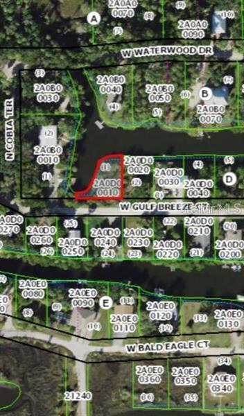
12119 Gulf Breeze Court, CRYSTAL RIVER, FL 34429
Priced at Only: $150,000
For more Information Call
Mobile: 352.279.4408
Address: 12119 Gulf Breeze Court, CRYSTAL RIVER, FL 34429


Property Location and Similar Properties
- MLS#: TB8401114 ( Land )
- Street Address: 12119 Gulf Breeze Court
- Viewed: 8
- Price: $150,000
- Price sqft: $0
- Waterfront: Yes
- Wateraccess: Yes
- Waterfront Type: Canal - Saltwater
- Year Built: Not Available
- Bldg sqft: 0
- Days On Market: 11
- Additional Information
- Geolocation: 28.8963 / -82.6361
- County: CITRUS
- City: CRYSTAL RIVER
- Zipcode: 34429
- Provided by: LUXURY & BEACH REALTY INC
- Contact: Maria Gallace Gerelus
- 727-800-5906

- DMCA Notice
-
DescriptionBeautiful canal lot waiting for you to build your dream home. Tucked away on Floridas west coast with great flats fishing, kayaking, paddle boarding and glorious sunsets. Large waterfront with access to the Gulf of Mexico.Close to the springs in Crystal River and scalloping.Just north of Old Homosassa with its endlaess entertainment, award winning restaurants and local artistry
Features
Waterfront Description
- Canal - Saltwater
Home Owners Association Fee
- 0.00
Carport Spaces
- 0.00
Close Date
- 0000-00-00
Country
- US
Covered Spaces
- 0.00
Current Use
- Residential
Garage Spaces
- 0.00
Insurance Expense
- 0.00
Legal Description
- WOODS 'N WATERS UNREC SUB LOT 1 BLK "D" MORE PART DESC AS FOLLOWS: COM NE COR SEC 24 TWN 18S RNG 16E PER PLAT BY MARION ENGINEERING ASSOC OF SURVEY FOR MAIRD-JOHNSON & RANDALL SEPT 23 1958; THN S 0 DEG 37M 44S E 102.30 FT THN S 0 DEG 37M 10S E 1419.3 1 FT TO POINT ON CTRLINE STATE RD NO. S-44 (KINGS BAY EXT SEC 02620-16-1) THN CONT S 0 DEG 37M 10S E 1118.20 FT TO CONCRETE MONUMENT SHOWN ON AFOREMENTIONED PLAT BY MARION ENGINEERING ASSOC THN N 89 DEG 58M 35S W ALONG S LINE JOHNSTON & RANDALL LANDS SHOWN ON SAID PLAT 857.61 FT THN S 0 DEG 37M 10S E 465 FT THN S 89 DEG 58M 35S E 175 FT TO POB; THN CONT S 89 DEG 58M 35S E 105 FT THN N 0 DEG 1M 25S E 87.76 FT MOL TO CANAL WATERS THN ALONG SAID WATERS S 88 DEG 43M 20S W 42.85 FT THN S 19 DEG
Living Area
- 0.00
Area Major
- 34429 - Crystal River
Net Operating Income
- 0.00
Open Parking Spaces
- 0.00
Other Expense
- 0.00
Parcel Number
- 16E-18S-24-0000-2A0D0-0010
Property Type
- Land
Sewer
- Public Sewer
Tax Year
- 2024
Township
- 18
Utilities
- Water Available
Water Source
- Public
Zoning Code
- CLR

- Jim Tacy, Broker
- Tropic Shores Realty
- Mobile: 352.279.4408
- Office: 352.556.4875
- tropicshoresrealty@gmail.com